- To develop and test a regional scale approach that combines modeling, data from remote sensing, sample surveys and intensive research sites to better estimate variation in the carbon balance of forest ecosystems in the Pacific Northwest
- To apply our strategy to investigate how processes controlling variation in net ecosystem productivity are influenced by forest development, disturbances and contrasting climatic conditions
Scaling Methods, Validation, and Results Across Major Forest Types and Age Classes
Key Findings
Net ecosystem productivity (NEP) is a critical characteristic of terrestrial ecosystem response to environment. Processes controlling NEP operate on a variety of temporal and spatial scales and are influenced by physiology, allocation, forest development, climate and disturbance. We used a spatially nested hierarchy of field and remote-sensing observations and a process model, Biome-BGC, to produce a carbon budget for the forested region of Oregon, and to determine the relative influence of differences in climate and disturbance among the ecoregions on carbon stocks and fluxes.
The simulations suggest that the net annual updake (NEP) for the whole forested region (8.2 million hectares) was 13.8 Tg C (168 g C m-2 yr-1), with the highest mean uptake in the Coast Range ecoregion (226 g C m-2 yr-1), and the lowest mean NEP in the East Cascades (EC) ecoregion (88 g C m-2 yr-1). Carbon stocks totaled 2765 Tg C (33 700 g C m-2), with wide variability among ecoregions in the mean stock and in the partitioning above- and belowground. The flux of carbon from the land to the atmosphere that is driven by wildfire was relatively low during the late 1990s (~0.1 Tg C yr-1), however, wildfires in 2002 generated a much larger C source (~4.1 Tg C). Annual harvest removals from the study area over the period 1995–2000 were ~5.5 Tg C yr-1. The removals were disproportionately from the Coast Range, which is heavily managed for timber production (approximately 50% of all of Oregon’s forest land has been managed for timber in the past 5 years). The estimate for the annual increase in C stored in long-lived forest products and land fills was 1.4 Tg C yr-1. Net biome production (NBP) on the land, the net effect of NEP, harvest removals, and wildfire emissions indicates that the study area was a sink (8.2 Tg C yr-1). NBP of the study area, which is the more heavily forested half of the state, compensated for ~52% of Oregon’s fossil carbon dioxide emissions of 15.6 Tg C yr-1 in 2000.
The Biscuit Fire in 2002 reduced NBP dramatically, exacerbating net emissions that year. The regional total reflects the strong east–west gradient in potential productivity associated with the climatic gradient, and a disturbance. Model outputs are being tested using detailed ecosystem studies at intensive sites, more basic ecological measurements at other existing intensive sites, and survey data from Forest Health Monitoring (FHM), Forest Inventory and Analysis (FIA) plots, and Current Vegetation Survey (CVS) plots. In spatially explicit applications, we are predicting and evaluating forest productivity for an east-west longitudinal swath along a steep climatic gradient through central Oregon from the coast to the semi-arid east side of the Cascade Mountains, and a north-south latitudinal swath from the southern Oregon border to southern Washington. These swaths encompass:
- Six Oregon Transect Ecosystem Research (OTTER) project sites across central OR.
- Two tower flux sites in young and old ponderosa pine (green stars at Metolius).
- Two tower flux sites in young and old Douglas-fir/hemlock in WA (green star at Wind River).
- Long-term vegetation plots at HJ Andrews LTER.
- Cascade Head Experimental Forest.
- FHM, FIA, CVS survey data for the PNW region (not shown).
- 36 intensive field sites (at Cascade Head, HJ Andrews, and Metolius).
- 60 extensive field sites (red triangles).
With BIOME-BGC, a physiologically-based process model, we are generating current NEP, NPP, and "carbon stress index" surfaces for the regions for a mean climate year, 1999, and 2000. We will use STANDCARB, an ecosystem process model, to estimate current carbon pools by accounting for long-term trends in NEP. BIOME-BGC will be initialized using remote sensing (Thematic Mapper) estimates of forest cover type, age class and LAI and soil survey data (FHM, STATSGO). The model is driven by spatially distributed climate data based on interpolations of weather station data by the PRISM and DAYMET models. Remotely sensed variables are validated with data from intensive sites, FHM, FIA, CVS, and new measurements in underrepresented forests. Short-term predictions (monthly, annual) of NEP are validated against tower flux data. Annual predictions of aboveground NPP and its components are validated with intensive site measurements of stemwood and litter production. Predictions of carbon stores are validated with FHM, FIA, and CVS data. We are evaluating sensitivity of NEP to forest type, developmental stage, disturbance, and interannual variability.
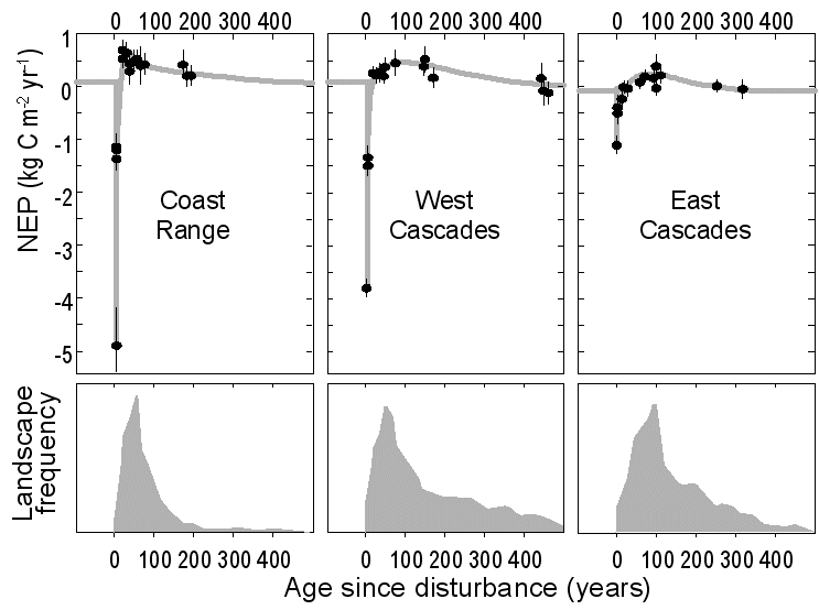
Figure 1. Successional trends in NEP measured at three climatically-distinct ecoregions in Oregon and the current distribution of forest ages throughout each ecoregion. Each point represents an independent forest study plot excepting the zero points which were back calculated from the next oldest stands. Error bars represent measurement error expressed as 90 percent confidence intervals.
