Projects
AmeriFlux
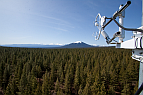
Metolius Cluster
The Metolius cluster is composed of two research sites: the Metolius Mature Pine site (US-Me2) and the…
Continue to full descriptionTERRA-PNW
Forest Mortality, Economics and Climate change in western North America
Our primary goal is to understand the interactions and the feedbacks by which human decisions and forest ecosystems influence each other. We are using the Community Land Model (CLM) to predict tree mortality due to droughts, fires, and insect attacks. We also focus our efforts on the coupling between CLM and economic models to elucidate the interactions and feedbacks among climate, tree mortality, and economic factors. To our knowledge, this work represents the first effort to couple state-…
Continue to full description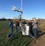
Carbon dynamics within Oregon's urban-suburban-forested-agricultural landscapes
DOE/USDA
PIs: B.E. Law, A. Schmidt, C. Still, T. Hilker
Land management strategies and land use within urban-suburban, agricultural and forested landscapes can have significant impacts on local and regional carbon, water and energy cycles, but their gross and net effects are complex and not well understood. As a result, a better understanding of the interactions and feedbacks between ecological systems, human actions, and changes in climate is…
Continue to full descriptionPast Projects
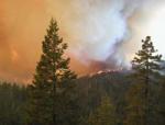
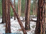
Biscuit Fire Study
Investigating carbon, vegetation and wildlife dynamics on the Biscuit: effects of wildfire, reburn and post-fire logging
The annual exchange of CO2 between forests and the atmosphere can be profoundly affected by wildfire, especially in regions like the Pacific Northwest where forest biomass potential is relatively high. The pulse of carbon released to the atmosphere by large-scale fire events such as the Biscuit may reduce the net annual uptake of carbon by Oregon forests by as much…
Continue to full description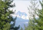
COHO Project
Regional Analyis of CO2 and H2O Exchange Over Heterogenous Terrain
Funding provided by NASA
Investigators: Larry Mahrt, Bev Law, and Mathew Williams
Climate Variabililty
Influence of Climate Variability on the Productivity and Distribution of Ponderosa Pine Ecosystems in the Pacific Northwest: Combination of a Process-Based Model and a 102-Year High Resolution Climate Data Set.
Integrating microwave and hyperspectral remote sensing for estimating vegetation structure and biomass
The possibility of global, three-dimensional remote sensing of forest structure with interferometric synthetic aperture radar (InSAR) bears on important forest ecological processes, particularly the carbon cycle. InSAR supplements two-dimensional remote sensing with information in the verticaldimension. Its strengths in potential for global coverage complement those of lidar, which has the potential for high accuracy vertical profiles over small areas. InSAR derives its sensitivity to forest…
Continue to full description
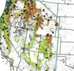
Oregon California Forest Carbon (ORCA)
Synthesis of Remote Sensing and Field Observations to Model and Understand Disturbance and Climate Effects on the Carbon Balance of Oregon and Northern California
The project tests and demonstrates the bottom-up and top-down paradigm of the North American Carbon Program. To quantify and understand the carbon budgets of Oregon and northern California (Figure 2), a spatially nested hierarchy of field and satellite remote sensing observations is combined with a widely-used prognostic…
Continue to full description
Quality Assurance and Control
AmeriFlux is a network of 92 long-term research sites across North America measuring the exchange of water vapor, sensible heat, and carbon fluxes between the atmosphere and biosphere using the eddy covariance technique. As with every precision measurement endeavor, there are sources of systematic and random error resulting from variances in hardware, software, and the instrument installation. To reduce and quantify these uncertainties, the AmeriFlux quality assurance and quality control (QA…
Continue to full description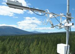
AmeriFlux Network
Nations of the world face challenges in developing sound policies and directions for addressing global change. The scientific community has the responsibility to provide the scientific basis for those policies. This includes developing the understanding of the influence of land, ocean and atmospheric processes in climate change. The goal of AmeriFlux is to develop a coordinated research network of long-term flux sites in the Americas for quantifying and understanding the role of the…
Continue to full description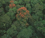
Amazonian Forests
Carbon emissions from deforestation and forest degradation have been estimated to contribute 12–20% of total anthropogenic CO2 emissions, ranking as the second largest source of CO2 to the atmosphere, after fossil fuel burning. Global monitoring of forest biomass is therefore critical to understanding the global carbon balance, and to support international agreements on greenhouse gases and carbon markets.
Currently, remote sensing approaches used for verifying carbon fluxes from…
Continue to full description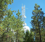
Regional Analysis of Net Ecosystem Productivity (NEP) of Pacific Northwest Forests
Scaling Methods, Validation, and Results Across Major Forest Types and Age Classes
Key Findings
Net ecosystem productivity (NEP) is a critical characteristic of terrestrial ecosystem response to environment. Processes controlling NEP operate on a variety of temporal and spatial scales and are influenced by physiology, allocation, forest development, climate and disturbance. We used a spatially nested hierarchy of field and remote-sensing observations and a…
Continue to full description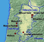
Current and Future Regional Carbon and Water Cycling
We have an ongoing research program in the western US supported by NOAA and DOE. We are improving representation of terrestrial processes, such as carbon allocation in forests and drought-induced mortality in the Community Land Model (CLM4.5), the land model portion of the Community Earth System Model (CESM 1.2) (DOE support).
We are currently working on:
- Improving representation of terrestrial biogeochemical processes in…