CO2
Long-term research site
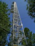
The Metolius Mature Pine site was established in 2001. It is located in a mixed-age ponderosa pine stand on Green Ridge in the eastern Cascade mountains of Oregon, about 30 km northwest of the town of Sisters. The stand was initiated ca. 1915, but the mean stand age is 71 years old, and the oldest 10% of trees are about 108 years old. The tower is 34 m tall and equipped with a full complement of eddy covariance instrumentation and a vertical profile of CO2 and meteorological data collection, powered by solar panels and a wind generator. The site is also equipped with a horizontal array of instrumentation collecting data on temperature, soil respiration, sapflow, and tree growth, and contributes data to the CO2 concentration project. The Metolius Mature Pine site has been selected for a trial installation of the COSMOS Neutron Soil Moisture Probe network, in collaboration with the University of Arizona.
The Mature Pine site is one of the Metolius core cluster sites with different age and disturbance classes and part of the AmeriFlux network. The overstory is almost exclusively composed of ponderosa pine trees (Pinus ponderosa Doug. Ex P. Laws) with a few scattered incense cedars (Calocedrus decurrens (Torr.) Florin) and has a peak leaf area index (LAI) of 2.1 m2 m-2. Tree height is relatively homogeneous at about 18 m, and the mean tree density is approximately 339 trees ha-1 (Irvine et al., 2008). The understory is sparse with an LAI of 0.2 m2 m-2 and primarily composed of bitterbrush (Purshia tridentata (Push) DC.) and greenleaf manzanita (Arctostaphylos patula Greene). Soils at the site are sandy (69%/24%/7% sand/silt/clay at 0–0.2 m depth and 66%/27%/7% at 0.2–0.5 m depth, and 54%/ 35%/11% at 0.5–1.0 m depth), freely draining with a soil depth of approximately 1.5 m (Irvine et al., 2008; Law et al., 2001b; Schwarz et al., 2004).
Archived meteorological data and field notes by year.
View site details and instrumentation specifications on the AmeriFlux website (links to external page).
Cellular modems are used to provide remote connection to the site. Loggers are polled regularly and data files are updated once per hour. The provided data has been downsampled to minimize file size. Data has not been quality checked and periodic outages may occur.
MP towertop logger (opens new tab)
MP subcanopy logger (opens new tab)
Questions or comments? Please contact us!


Automated soil respiration chambers

34 meter walk-up tower

Meteorological sensors measuring wind speed and direction, and air temperature and relative humidity