Research Sites
Flux Sites
Metolius Mature Pine AmeriFlux Site (US-Me2)
Long-term research site
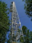
The Metolius Mature Pine site was established in 2001. It is located in a mixed-age ponderosa pine stand on Green Ridge in the eastern Cascade mountains of Oregon, about 30 km northwest of the town of Sisters. The stand was initiated ca. 1915, but the mean stand age is 71 years old, and the oldest 10% of trees are about 108 years old. The tower is 34 m tall and equipped with a full complement of eddy covariance instrumentation and a vertical profile of CO…
Continue to full description

Metolius Young Pine Burn AmeriFlux Site (US-Me6)
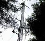
The Metolius Young Pine Burn site was established in 2010 and is part of the Metolius cluster sites with different age and disturbance classes within the AmeriFlux network. It is located on the east side of the Oregon Cascade mountains near the town of Sisters. The tower is 18.6 m tall and equipped with a full complement of eddy covariance instrumentation on the vertical profile. The site is also equipped with a horizontal array of instrumentation collecting data on temperature, soil respiration, sapflow, and tree growth, and contributes data to the CO2 concentration project.…
Continue to full description

Hybrid Poplar Flux Site (US-Wpp)
The site was established in fall 2014 and is part of a eddy covariance flux tower network funded by DOE and USDA. It is also a part of the AmeriFlux network (US-Wpp). The hybrid poplar plantation is located in the Willamette Valley in Oregon on a property that is managed by the cities of Eugene and Springfield, OR. The location is part of a waste water managing facility and the poplar trees are irrigated and fertilized with pre-treated waste water. The plantation covers three different age classes and various hybrids of…
Continue to full description
Agricultural Wheat Flux Site (US-Wwt)
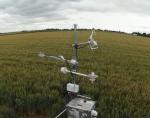
The site was established in summer 2014 and is part of a eddy covariance flux tower network funded by DOE and USDA. The Willamette Wheat site is also a part of the AmeriFlux network (US-Wwt). Turbulent exchange of water vapor, carbon dioxide and heat is measured at this tripod tower as well as meteorological variables. The structure is moved twice annually between two adjacent fields where winter wheat and spring wheat, respectively, is grown. The site is also part of the…
Continue to full description

Agricultural Grass Flux Site (US-Wgr)
The site was established in summer 2014 and is part of a eddy covariance flux tower network funded by DOE and USDA. The Willamette Grass site is also part of the AmeriFlux network (US-Wgr). Meteorological variables such as temperature, humidity, solar irradiance and wind are measured at this site. Turbulent fluxes of water vapor, carbon dioxide and heat are observed and stored as 30 minute averages. At this site the crop changes periodically and rye grass and fescue is grown alternately at this site located in Oregon's…
Continue to full description
Marys River Fir AmeriFlux Site (US-MRf)
The Marys River Fir site was established in 2006. It is located in a Douglas-fir stand planted in 1976, in the Oregon coast range near the town of Summit. The tower is 40 m tall and equipped with a full complement of eddy covariance instrumentation and a vertical profile of CO2 and meteorological data collection. The site is also equipped with a horizontal array of instrumentation collecting data on temperature, soil respiration, sapflow, and tree growth, and contributes data to the CO2 concentration project. The site is powered by solar panels and a backup generator.
…
Continue to full description
CO2 Sites
Silverton CO2 Observation Site (OSI)
The Silverton CO2/CO monitoring site is on a 269m tower located at the eastern edge of Oregon’s Willamette Valley. The site came online in June 2012. It is located east of the town of Silverton in Oregon's central Willamette Valley. Gas analysis is performed with a Picarro 2302 Cavity Ringdown Spectrometer, and the tower is also equipped with a set of meteorological instruments, including an HMP sensor, a radiation sensors, and an anemometer.
CO2/CO/H2O data are submitted to NOAA's Global Greenhouse Gas Reference Network Observation…
Continue to full description

Burns CO2 Observation Site
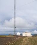
The site was established in 2012 and is part of a NOAA observation network for high precision measurements of carbon dioxide concentrations. It is located about 60 km southwest of Burns, Oregon in the Oregon High Desert. The vegetation in this area is dominated by sagebrush. The sampling inlets are at the heights of 18.5, 28.5, and 38.5 m. Gas analysis is performed with a Picarro 2302 Cavity Ringdown Spectrometer and a Li-Cor 7200 enclosed path IRGA. The tower is also equipped with a set of meteorological instruments, including an HMP sensor, radiation sensors (incoming and diffuse PAR,…
Continue to full description

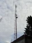
Marys Peak CO2 Observation Site
The Mary's Peak site was established in 2006. It is located on top of Mary's Peak, the highest mountain in the Oregon coast range. The sampling inlet is 10 m up on the tower, and gas analysis is performed with a Picarro G2302 Cavity Ringdown Spectrometer. The tower is also equipped with a set of meteorological instruments, including a radiation sensor and a heated anemometer with vane specifically developed for the harsh mountain conditions in winter. Due to its exposed position the tower measures background CO2 values of incoming air from the Pacific during stable conditions with westerly…
Continue to full description
Walton CO2 Observation Site
The Walton tower is located in the center of the Oregon Coast range, about 44 km west of Eugene, OR and about 4 km northeast of the small town of Walton, OR. The tower is located on a hilltop, with no significant sources of anthropogenic emissions in the near field footprint. The mixing ratio time series captured at the Walton tower show significant effects of CO2 release and uptake by the surrounding Douglas-fir forest, and are intended to provide information on the effect of climate variability on the very active mesic forest ecosystems along the West Coast. Observations at…
Continue to full description